Vermont Prone to Flooding: Then and Now
By James Steele
This week, a USA Today headline screamed: “Dramatic flooding was rare in Vermont’s capital. Expect it more amid climate change.” Similar hyperbolic claims appeared throughout the click-bait media-verse of the New York Times, Washington Post, CNN and others.
Preferring to weaponize weather, the media rarely provide scientific historical context. Perspective is just not their thing.
However, a more complete account of floods in the Green Mountain State is in a 2002 article by the Vermont Historical Society, “Climate Variability and Socioeconomic Consequences of Vermont’s Natural Hazards: A Historical Perspective.” The article states:
One of the most pervasive hazards that impinges upon and marks the Vermont landscape is flooding … Rarely does a year elapse without a flooding event of a significant magnitude being reported in at least one of Vermont’s fourteen counties or perhaps statewide, making this the number-one hazard across the state.
This historical society piece continues:
“Complex topographic barriers such as the Green Mountains and Taconics produce enhanced precipitation totals … Vermont’s steep V-shaped valleys help to constrain the flow, creating remarkable depths of flow at tremendous speeds. As far back as 1853, (naturalist and historian) Zadock Thompson noted these topographic characteristics along the Winooski, Lamoille, and Missisquoi rivers, such that by default, roads could only be constructed along the open valley floors, making them susceptible to flooding damage.
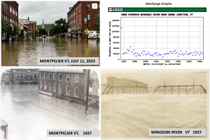
“The Great Flood of 1927 resulted from record rainfall totals produced by tropical storm remnants on November 3, following October precipitation totals that were already 50 percent above normal. As this decaying storm tracked directly along the spine of the Green Mountains, streams rose so rapidly that there was little time for warning. The Winooski River rose 40–45 feet above its normal level, causing an estimated $30 million in economic losses. The Montgomery flood of July 15, 1997, In the towns of Montgomery, Montgomery Center, Lowell, and Wolcott at least 6 inches of rain fell in less than six hours.
“Montpelier is particularly prone to flooding given its location in the Winooski River valley just upstream from the confluence with the Dog River.”
Below are pictures of Montpelier flooding in 2023 and 1927. In contrast to claims that global warming is causing more floods, U.S. Geological Survey records show not a hint of an upward trend. Also pictured is the raging Winooski River in 1927.
James Steele is a biologist, author and former director San Francisco State University’s Sierra Nevada Field Campus. He is a member of the CO2 Coalition.