A Growing Sea of Snags: North Umpqua River Wildfires, 2002-2022 – Risks and Recommendations
Bob Zybach – January 26, 2022
The September 8, 2020 Labor Day Fires in western Oregon burned nearly a million acres of land in a three-day period, killed 11 people, destroyed more than 4,000 homes, polluted the air with toxic smoke for nearly two weeks and killed millions of native wildlife. Of these amounts, the Archie Creek Fire, along the North Umpqua River, was responsible for one human death, more than 150 people losing their homes, and over 131,000 acres, mostly forested, being burned. Due to the fire’s large size and rapid spread, mortality of native plants and animals approached 100% within much of the fire’s perimeter (see Figures 1 and 2).
These fires were typical of catastrophic-scale wildfires of the past 35 years in that they began and grew from federal lands — USDA National Forest System and USDI Bureau of Land Management (BLM) forestlands. They were atypical in that they also spread rapidly through thousands of acres of industrial timberlands, family farms, recreational developments, and rural communities.
The Labor Day Fires exploded on strong east winds and took place from the California border to the Columbia River. Fuels included millions of snags from earlier fires, crowded mobile homes and trailer parks, “critical habitat” designations, streamside “buffers,” roadless areas, industrial plantations, stands of old-growth (trees older than 200 years), and second-growth (merchantable trees less than 200 years). Most trees and snags burned in these events were Douglas fir, but all species of trees, shrubs, and grasses were quickly killed or consumed.
This report is organized in three parts:
- How snags from previous North Umpqua River basin fires affected the Archie Creek Fire (see Map 1, Table 1).
- The increasing risks that unsalvaged snags from the 2002-2021 fires will affect human health and safety, transportation and powerline corridors, private property, wildlife populations, and recreational opportunities (p. 10).
- Recommendations (7) to mitigate effects of Archie Creek Fire and reduce risks of future North Umpqua fires of this magnitude, as a case study (p. 18).
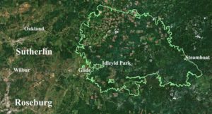
Figure 1. Satellite imagery of North Umpqua River basin and local communities before Archie Creek Fire, August 2020. Image courtesy Mason, Bruce & Girard.
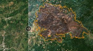
Figure 2. Satellite imagery of North Umpqua River basin following Archie Creek Fire, September 2020. Image courtesy Mason, Bruce & Girard.
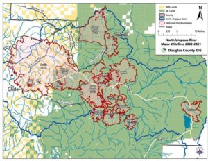
Map 1. Major Forest Fires of the North Umpqua River Basin, 2002-2021. Note northern boundary of 2021 Chaos Fire closely following ridgeline separating Willamette and Umpqua River basins; other ridgeline and riparian firebreaks.
| Year | Date | Wildfire Name | Acres | Snags | Ownerships |
| 2002 | 0816 | Apple | 17,600 | Yes | USDA Umpqua NF |
| 2008 | 0813 | Rattle | 19,800 | Yes | USDA Boulder Creek Wilderness |
| 2009 | 0912 | Boze | 10,600 | Yes | USDA NF |
| 2009 | 0912 | Rainbow | 6,100 | Yes | USDA NF |
| 2009 | 0728 | Williams Creek | 8,400 | Yes/No | USDA NF/Private |
| 2015 | 0728 | Cable Crossing | 1,900 | Yes/No | USDI BLM O&C/Private |
| 2017 | 0808 | Fall Creek | 4,800 | Yes | USDA NF/USDI BLM |
| 2017 | 0808 | Happy Dog | 31,400 | Yes | USDA NF |
| 2017 | 0808 | Twin #1 | 1,400 | Yes | USDA NF |
| 2017 | 0808 | Brokentooth | 3,700 | Yes | USDA NF |
| 2020 | 0908 | Thielsen | 9,800 | Yes | USDA NF |
| 2020 | 0908 | Archie Creek | 131,500 | Yes/No | USDA NF/USDI BLM/Private |
| 2021 | 0705 | Jack Creek | 24,000 | Yes/No | USDA NF |
| 2021 | 0730 | Chaos | 28,800 | Yes | USDA NF |
| 2021 | 0730 | Buckhead | 7,200 | Yes | USDA NF |
| 2021 | 0730 | Little Bend Creek | 9,400 | Yes | USDA NF |
Table 1. Historical North Umpqua River Wildfires, 2002-2021.
I. How snags affected the 2020 Archie Creek Fire
A wildfire’s severity depends on three things: fuels, topography (slope and aspect), and weather (primarily wind, temperature, and humidity, including precipitation). After an area burns in the Douglas fir forests of western Oregon, green trees filled with water are soon converted to standing, air-dried firewood filled with pitch — “snags.” Snags are the standing dead trees typically created by fire, bugs, overstory shade, disease, or by purposeful human action, such as physically girdling a tree or injecting it with poisons. When ignited, these massive fuels can be difficult or impossible to extinguish, depending mostly on need, available tools, access, and wind.
Throughout recorded history, virtually every major wildfire in western Oregon has been caused by people or by lightning — eruptions of Mt. St. Helens and Mt. Hood forest fires were unusual exceptions. Dry lightning strikes typically occur on a seasonal basis in specific locations that can be predicted — and volcanic eruptions are infrequent — but people use fire on a daily basis, travel everywhere, and fires can be readily set by careless smokers, campfires, motors, powerlines, arsonists or by other means on a year-round basis almost anytime, anywhere.
A fire creates its own weather. Historic catastrophic-scale wildfires (greater than 100,000 acres) in western Oregon have all been driven by dry east winds, including the unprecedented 2020 Labor Day Fires. When these events take place, they are difficult to contain or control, and it is almost always necessary to wait until Fall or Winter snows and rains to fully extinguish them.
Due to the heavy east winds, massive fuels, and several sources of human ignition, the Labor Day Fires — including Archie Creek — burned westward through the river valleys of the western Cascades like a blowtorch, even moving through the night and killing nearly everything in their paths. The presence of snags in this environment was almost invisible — everything burned, snags included.
Prior to the 2009 Williams Creek Fire, the area of the Archie Creek Fire was virtually snag-free. Osborne photographs taken from six separate fire lookouts in 1933 showed a vast landscape of mostly even-aged stands of old-growth and second-growth Douglas fir (e.g., Figure 3). There were scattered snags in the Mace Mountain Lookout area (see Map 2: Tsp. 25 S., Rng. 1 W., Sec. 31; headwaters of Fairview, Fall, Mace, and Cougar Creeks), but these may have been purposefully removed by local CCC crews in the later 1930s, or by other means, and were largely gone by the 1950s (Thornton, personal communication: August 21, 2021).
Figures 3 and 4 show the same general viewpoint from the Mount Scott Lookout (see Map 2: Tsp 25 S., Rng. 3 W., Sec. 28; Rock Creek basin). Subsequent aerial photos taken in the 1970s and 1980s (Figure 5) showed increasingly large areas of clearcuts and logging roads in the Mount Scott area but no evidence of large fires or significant numbers of snags.
Historical records of seasonal weather patterns in western Oregon have been consistent for many decades, and the related regional fire seasons in which threats of a major wildfire might take place, have remained remarkably consistent. For the past 20 years, the primary ignitions of major wildfires in the North Umpqua basin have taken place from July 28 to September 12 (see Table 1): a 47-day period that has likely been mostly consistent for several centuries. These fires all ended with Fall rains and snow and did not persist through the Winter.
Map 1 and Table 1 also show the number of large-scale fires has increased dramatically on the North Umpqua during the past 20 years, and particularly on Umpqua National Forest Land. Following the Archie Creek Fire, the USDA Rapid Assessment Team noted (USDA RAT 2020: 7):
Over the past 20 years, 28% of the Umpqua has burned in wildfires, with the total acreage being higher due to several areas being burned two to three times over the past 20 years. Less than 1% of these past fires in total have been salvaged, with the majority of snag loss occurring along roadsides as danger tree mitigation to keep open public access. Therefore, snag abundance at the landscape level will likely be above the 80% tolerance level on the North Umpqua and Diamond Lake Ranger Districts for quite some time.
The important statement in this quote is “several areas . . . burned two or three times over the past 20 years.” After the 2020 RAT report was written, the 2021 Jack Fire, Chaos Fire, and the Rough Patch Complex wildfires burned more than 70,000 additional acres on the North Umpqua, and all within the Umpqua National Forest. Thus, the total acreage burned on the Umpqua National Forest in the last 20 years, including the 2021 wildfires, measures about 40% of the entire Forest, depending how reburned areas are counted. This “fire return interval” between wildfires challenges the characterization of the area as a 200- to 800-year “fire regime,” as some have postulated (e.g., Nonaka and Spies 2005; Zybach 2016). Similarly, repeated high intensity fires may ultimately convert the forest to another vegetation type altogether (e.g., Hansen 1947).
Figure 3 is the view east and southeast of the historic Mount Scott Lookout, taken in August 1933. This lookout had been in operation since 1914 but was destroyed in the Archie Creek Fire. Figure 4 shows the same directional view from the same location, taken by a “fire detection camera” in August 2021, magnified 1.5 times.
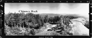
Figure 3. Osborne photograph, view east and southeast from Mount Scott fire lookout, by Albert Arnst and Lester Moe, August 20, 1933.
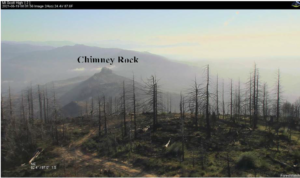
Figure 4. View east and southeast from location of destroyed Mount Scott fire lookout, August 19, 2021. Photograph courtesy of Melvin Thornton, Douglas Forest Protective Association (DFPA) fire detection camera, 1.5x magnification.
It is interesting to note the second-growth trees in the 1933 photo that block the view of Chimney Rock, may have formed the relatively small old-growth snags in the 2021 photo, due to the poor growing conditions for Douglas fir on the east slope of Mount Scott. Of additional interest is the fact that these snags likely pose little future wildfire risk because of their remote setting, small size and wide spacing. The visible smoke in Figure 4 is from the 2021 Jack Fire to the east.
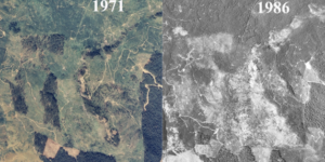
Figure 5. Square-mile aerial views of Mount Scott Lookout (center), 1971 and 1986. These photos were provided by University of Oregon Map & Aerial Photography Library. By aligning roads in each photograph, it is clearly shown that most of Mount Scott (Scott Mountain) had been logged or grazed by 1971; that much of the remaining forestland had been harvested in the following 15 years; and how thoroughly the previous unforested areas had become forested. Everything within the boundaries of these photos, including the historic Mount Scott Lookout Tower, subsequently burned during the Archie Creek Fire.
On the North Umpqua, heavy concentrations of snags remained from the 2009 Williams Creek, 2015 Cable Crossing (see Figure 6), and 2017 Fall Creek Fires. The eastern-most ignition point of the Archie Creek Fire apparently started in the vicinity of the Williams Creek snags and quickly traveled westward, through the previous Fall Creek and Cable Crossing burns. Map 1 seems to indicate that these three locations may have helped accelerate the fire in a wider arc to the west.
Figure 7 shows snags remaining from the 2002 Apple Fire that reburned in the 2021 Jack Fire.
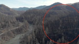
Figure 6. Reburned snags remaining from 2015 Cable Crossing Fire (drone videoclip by Matt Hill, Douglas Timber Operators (DTO), December 2020).
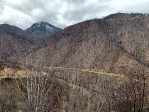
Figure 7. Reburned snags remaining from 2002 Apple Fire (drone videoclip by Hill, DTO, April 2022).
Note the missing bark, limbs, and fine fuels on reburned snags in foreground on Figure 6, and evidence of salvaged snags on private land in the background within the red circle. Also note the burned trees within the Cable Crossing Fire area that had initially survived that event; the dried fine fuels and limbs remaining on them after they were killed during the Archie Creek Fire; and the same pattern of fine fuels remaining on the new snags now lining the North Umpqua River.
Figure 7 shows an area of the Umpqua National Forest that was naturally and artificially reforested with seedlings and saplings following the 2002 Apple Fire, and which were then consumed by the 2021 Jack Fire. This latter event also killed the parent seed trees that remained from the earlier fire, as with the Cable Crossing reburn history.
According to Douglas County 911 records, made available by the Douglas County Sherriff’s Office, one of the earliest reports of the Archie Creek Fire was observed among the snags remaining from the 2009 Williams Creek Fire (911 call from Chris Canty, September 8, 2020, 3:49 A.M.):
Yes, I’d like to report a fire . . . it’s in between Bogus Creek and Williams Creek, off of [Highway]138 . . . I can see two separate [fires] . . . the one I saw was 20 acres at least . . . it’s burning the old Williams Creek Fire scar.
DFPA (Douglas Forest Protective Association) District Manager Pat Skrip also recalls the earliest report of a fire on the upper North Umpqua River as being in the Williams Creek burn (videotaped interview with Matt Hill, December 2020):
. . . we got another report [after containing the French Creek Fire in Glide] of a fire up the North Umpqua, to the east of us. The reference was an old fire scar called the Williams Creek Fire near Steamboat.
II. Risks of untreated/unsalvaged snags to people, property, and wildlife.
Burning snags can greatly increase the heat and severity of a fire due to their flammability. The resulting intense fires can create their own weather patterns with high winds, cumulus clouds, lightning, and even rain. Firebrands can be spread more than a mile in advance of flames, creating spot fires where they land. In this manner, the historic 1902 Yacolt Fire and the more recent 2017 Eagle Creek Fire had firebrands that crossed the Columbia River from Oregon and started fires in Washington.
Melvin Thornton (personal communication: August 21, 2021) reported “10-foot- long burning limbs” being carried 2,000 feet into the air by wildfire updrafts. He also reports that the 2017 Stouts Creek Fire in the South Umpqua River basin burned so hot and rapidly its updrafts formed cumulus clouds and lightning whose strikes started at least two additional fires.
Attempts to manage or extinguish a wildfire are made many times more dangerous by burning snags. For this report, I conferred with several experts on the topic, three of whom have had significant professional experience working on the North Umpqua wildfires of the past 20 years:
- Chuck Sheley (editor, Smokejumper magazine)
- Melvin Thornton (DFPA District Manager, retired)
- Pat Skrip (DFPA District Manager, current)
- Dan Metz (Oregon Department of Transportation)
A point of public discussion in recent years has been why many of these fires were not directly attacked from the air while they were still small: sometimes personnel and wildfires were too widespread to effectively administer to all fires at one time; other cases involved seemingly poor decisions not to jump, according to some experts; and in other instances, conditions were simply too dangerous — including poor visibility and/or the presence of snags, burning or not.
According to Sheley (email correspondence: August 8, 2021):
I certainly don’t disagree with the problems created by snags in burned areas. Areas with dead snags are not jumped any more. They were definitely dangers during my era. Once you are on the ground and building fireline, snags are very dangerous. Whenever possible fallers would take down ones near the fireline.
Firefighting, road clearance, hazard tree removal, and other tasks associated with wildfire management and immediate post-fire repair on the North Umpqua are the primary responsibilities of the USDA Forest Service (USFS), USDI Bureau of Land Management (BLM), Oregon Department of Forestry (ODF), Douglas Forest Protective Association (DFPA), and Oregon Department of Transportation (ODOT).
These jobs are made significantly more hazardous in the presence of burning snags, particularly when the snags are only a year or two old, as in Figure 6. The older Cable Crossing Fire snags have mostly shed the limbs, twigs, tops, and needles that are still evident on the more recent Archie Creek snags. If these latter snags burn in the next year or two, they will probably shower burning embers and limbs on anyone working underneath them, likely ignite nearby ground fires, and possibly create wind-driven spot fires far in advance of the main body of the fire.
Another hazard is created when roots are burned out from a snag, and it falls and hurtles straight downhill. Local firefighters refer to these as “scud missiles,” because they are deadly to anyone in their path (Skrip, personal communication: July 2021). The risk of snags to firefighters will also increase over time (Skrip, videotaped interview with Hill, DTO: December 2020):
There are some public lands that will not be touched, and that is going to be a challenge for us. Those large heavy snags out there present a risk to our firefighters for engagement. Each year that they go on, they get a little weaker and what happens is that the brush component will start building up underneath them. Over the next 10 years, [there is] probably minimal threat with the new growth. But once you get beyond that, there is a higher risk on those unmanaged lands that is transferred across the landscape to adjacent landowners . . . currently in the DFPA [jurisdictional area] we have about 14% of our timber base that is in a large fire scar [that has developed] over the last 8 years.
The presence of historic levels of snags across the federal landscape in the proximity of the Umpqua National Forest, including Wilderness, BLM, and Crater Lake National Park, will undoubtedly affect future wildfire behavior. Experienced wildfire managers will likely be reluctant to directly attack fire in these circumstances, more acres will burn (or reburn) as a result, creating even more snags and likely pulling the North Umpqua into an ever-deeper spiral of forest destruction; i.e., continuation of the pattern characterized by the past 20 years.
Snags create a well-documented wildfire risk based on size, age, species, and distribution. They can also cause death and serious injury when they fall, damage understory plantations, roads, and buildings, and/or host harmful insects and diseases. Most people consider them unsightly blemishes on the landscape. Their greatest danger, though, is their flammability in a wildfire and the deadly and costly destruction that can directly result, whether as standing or ground fuels.
The “Six-Year Jinx” of 1933, 1939, 1945 and 1951 Tillamook Fires demonstrated how catastrophic-scale reburns can take place in western Oregon Douglas fir forests when snags are left in place. It wasn’t until the resulting great “Tillamook Burn” had been salvage logged, systematic firebreaks created, and reforested with the help of Oregon schoolchildren that the fires were finally stopped (Zybach 1982). The planted and artificially seeded land is now a beautiful State Forest that hasn’t burned in more than 70 years.
The Kalmiopsis Wilderness provides another example. No harvesting, road maintenance, or reforestation took place for more than 50 years, and then it burned and reburned in the 1987 Silver Complex, 2002 B&B, 2017 Chetco Bar, and 2018 Klondike Fires (Zybach 2017). In Douglas fir forests the lesson is clear: if snags are not removed or otherwise treated (typically by being felled and broadcast burned), they are almost certain to burn again — and often hotter and over a larger area than the fires that initially created them.
The burn and reburn cycle could take half a century (Skrip videotaped interview with Hill, DTO: December 2020):
. . . there is a risk there for about 40 years, without some pre-fire treatment or post-fire salvage. That leaves the communities at risk, that leaves our firefighters at risk, that leaves the state at risk for large fire costs.
This reburn cycle, if snags aren’t removed, also threatens post-fire reforestation efforts by federal, state, tribal and private landowners. Both BLM and the Forest Service conducted extensive replanting throughout high intensity burn areas within the Archie Creek Fire scar (see Figures 16-19). Much of this work was completed beneath standing snags that, if (or when) reburned, will reset this costly reforestation experiment to year zero (Missett 2022), as with the 2002 Apple Fire.
The 2020 Labor Day Fires also illustrated the real risk to rural residents and communities posed by the increasing numbers and expansions of wildfires in western Oregon. More than 4,000 individuals and families lost their homes, 11 people died, and millions of Oregonians breathed toxic smoke for days and weeks. The 2020 Archie Creek and 2021 Jack Fire evacuations clearly affected the residents and communities of Glide, Idleyld Park, Rock Creek, Dry Creek, Little River, and Steamboat. Snags remaining in these locations pose the greatest continuing threats to residents and their properties, both by burning and by falling. The smoke and ash from these fires created serious problems along the I-5 corridor, and particularly the greater communities of Roseburg and Sutherlin.
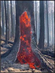
Figure 8. Burning Archie Creek snag that has likely burned at least twice before. Lessons from the 1933-1951 “Six-Year Jinx” Tillamook Fires and the 1987-2018 Kalmiopsis Wilderness Fires are clear: unless removed, the dead trees resulting from these fires will likely fuel ever greater and more severe wildfires. Forests of dead trees are far more flammable, dangerous, and unsightly than forests of living trees. Dead trees become air-dried firewood, and dead forests become firebombs that almost certainly will burn again and again, unless something is done to stop that process (Zybach 2003: 192-228). Photo by Jeff McEnroe, Roseburg BLM.
Figures 1, 9, and 10 show the increasing hazard to rural urban areas posed by these fires. In addition to the increased flammability of public forestlands caused by the accumulation of snags, growing green fuels have also been directly connecting these lands to nearby homes and businesses. Note the increasing numbers of trees and shrubs along the Umpqua River, within town, and moving in from hillsides that had been burned or grazed in earlier times. Also note the ever-increasing number of closely spaced, highly flammable, wooden structures that have been built in recent years. The destruction of homes and losses of life resulting from the Labor Day Fires were largely fueled by adjacent hillside and riparian vegetation that had developed uncontrolled during the past few decades.
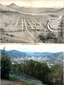
Figures 9 and 10. Roseburg, Oregon in 1884 and in 2008. Both perspectives are “from a rocky ledge” looking south: the drawing is from Albert Fagan’s “History of Southern Oregon,” and the photo is by BLM Forester, Abe Wheeler.
Figure 11, as an example, shows a tributary to Rock Creek from a concrete bridge downstream from the “streamside buffer” that remains along its banks. A few decades ago these trees would have never been allowed to grow in such close proximity to the creek, or (as snags) they would have been cut and burned or yarded away from its banks during the salvage logging and reforestation projects shown in the background.
Figure 11. Streamside buffer snags following salvage logging on Rock Creek tributary, July 19, 2021. Videoclip by McKenzie Peters, NW Maps Co.
There is some question as to whether these artificial buffers cause streams to run smaller, warmer, or even dry up seasonally, due to evapotranspiration from the weeds, shrubs, and trees that line their banks. After a wildfire, streamside snags will eventually uproot or break and fall over, and likely burn again. If they uproot, as shown in the photo, then soil will wash into the stream, causing unwanted siltation for fish. If they break, the downstream effect of fallen, floating trees on culverts, bridges, railways, and highways is predictable and preventable. The machine shown in the background could easily do the job needed to avoid these problems.
Figure 6 illustrates the same problem as Figure 11, but at a different scale. What will happen to these large snags along the North Umpqua the next few years? Will they be removed, possibly sold, or will they be allowed to fall into the river and float downstream during Winter floods? Or will they stand long enough to burn again?
Private properties are shown as white on Maps 1 and 2. Most of these properties are industrial timberlands that have already — within the past two years — been salvage logged and/or even planted, depending on their condition when they burned. Historically, industrial tree plantations have been mostly safe from wildfire, but tree farms in the Rock Creek basin are checkerboarded with square- mile, 640-acre (gold-color) BLM O&C Lands which may continue to contain large amounts of snags and downed wood. In many cases, BLM snags will likely fall on, or spread future wildfires to, adjacent private lands or public access roads, and remain a principal risk to these properties.
Phil Adams, Director of Timberlands for Roseburg Forest Products, has stated concerns along these lines for timberland he manages in the Rock Creek and Calapooya Creek basins (videotaped interview with Hill, DTO, August 2021):
We’re anticipating that the federal lands, especially here, the BLM properties in this area, won’t have much active management executed on them and we’ll see a lot of snag patches and brush fields on those properties that concern us greatly from a future fire resiliency point of view.
Because snags have largely been salvaged from private lands or are in the process of being treated for reforestation purposes, they will likely pose little recurring risk to wildlife on those lands. Rather, the greatest risk to wildlife is on federal lands in which snags and other flammable materials — such as fallen branches and trees, leaf litter, and exotic weeds — are allowed to develop and remain (see Figure 12).
Most campsites, trails, and other recreational developments affected by the Labor Day Fires are on federal lands. Local residents and visitors to these locations are threatened directly when dead limbs and trees or snags fall, and certainly during times of wildfire. The various roads connecting O&C Lands provide an exception to this general rule: people traveling these routes for recreational or other purposes, such as work or travel, may also be endangered or inconvenienced by falling snags or a related wildfire.
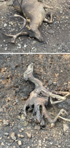
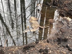
Figure 12. Deer hunting was a major recreational use of public forestlands burned in the Archie Creek Fire. These photos were taken by Lone Rock Timber Co. faller, Brook Pfaff, in September 2020 while clearing right-of-way to company lands in the Rock Creek basin as the fire was dying down. These tragic, painful deaths represent only a small fraction of the millions of wild animals and hundreds of species killed in the first 48 hours of the Labor Day Fires on September 8 and 9. Large animals able to fly or swim to deeper water mostly survived, but mortality of mammals, reptiles, amphibians, insects, and fish in shallow waters was nearly 100%. Populations will rebound, but this result could have likely been prevented.
III. Recommendations for 2020 Archie Creek Fire mitigation, as case study
Fires are largely bounded by ridgelines and streams, so managing snags in subbasin-scale units makes sense. For example, Figure 13 shows the ridgeline burn pattern bordering a portion of the Beachie Creek Fire that burned on the same days and under the same conditions as — but to the north of — the Archie Creek Fire. Prescribed fires are also typically contained within these boundaries, in part because of economic, safety, and smoke management purposes (Fraser 1982), but primarily due to natural and developed ridgeline and riparian firebreaks.
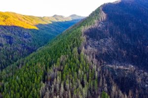
Figure 13. 2020 Beachie Creek Fire pattern, showing typical ridgeline burn boundary, January 18, 2021. Drone photo by Andy Adkins, Floating Point Films.
For purposes of this report, subbasins are defined as individual areas drained by named creeks tributary to the North Umpqua River, Rock Creek, or Calapooya Creek basins. In the Archie Creek Fire area most, if not all, subbasins are fish-bearing (see Map 2). Access roads and trails and endemic wildlife populations are also reasons for considering the effects of snags and wildfires within a subbasin. Roads and trails often follow named streams and ridgelines, which reinforces their value as firebreaks, and also provide residential, work, and recreational access. Most aquatic invertebrates, insects, reptiles, amphibians, fish, young birds, and small mammals spend their entire lives within the confines of a subbasin, so risk to native wildlife habitat must also be considered in that context.
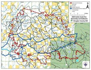
Map 2. Named subbasins and landownership patterns of the 2020 Archie Creek Fire. Note large blue polygon including residential properties and major transportation and powerline corridors.
Map 2 shows the named Archie Creek Fire subbasins can be considered with three basic ownership patterns: 1) the Calapooya Creek subbasins are mostly private industrial timberlands (white); 2) the Rock Creek subbasins are mostly composed of O&C “checkerboard” forestlands — that is, alternating square miles of USDI BLM lands (gold) with square miles of private, mostly industrial, timberlands; and 3) the mainstem North Umpqua subbasins are a mix of residential, recreational, industrial, O&C Lands and Umpqua National Forest (green).
The large, dark blue polygon on Map 2 includes all major forest ownership types, as well as commercial and residential properties, State Highway 138, and the primary powerlines corridor. For these reasons it is highly recommended that all snags be removed or carefully managed in these subbasins. This is where they are the most dangerous to people and property, and where future landscapes featuring native shrubs, bunchgrasses, and/or wildflowers might be safer and more attractive — and less costly to maintain.
However, snags have been largely retained on federal lands within this priority area because of various land designations such as Wild & Scenic Rivers and Late Successional Reserves (“LSRs”). Minor exceptions include small tree-length corridors along Highway 138, other public roads, and powerline right-of-ways.
The easiest method of reducing or eliminating this risk, and occasionally the most profitable, is to remove snags and danger trees periodically as they occur.
A. Subbasin-scale reforestation planning
Wildfires are typically bounded by ridgelines (Figure 13), waterways, or human developments such as roads, irrigated fields, or temporary firelines. Map 2 illustrates how these boundaries can cross different ownership types within a single subbasin, even though they rarely share common wildfire mitigation plans or forest management strategies.
Reforestation planning is usually based on ownership for several legal and political reasons (Zybach 1982; 2012; 2021c; 2022). Most plans are based on three basic components: site preparation, planting, and resulting stand maintenance. The implementation of these plans is largely dependent on physical access and funding. The goals of any plan are also restricted by existing and emerging laws and regulations, and by local economics. Understandably, federal and state lands give laws and regulations priority, while private landowners must put economics first.
The main budgeting difference between ownerships is whether taxes are being paid or being spent. For private forest landowners, timber is usually the primary crop for making an income and paying taxes. Public lands place more importance on wildlife habitat regulations, public recreation, and involving the public at some level in the planning process.
Post-fire fuels reduction planning on public lands is far more complicated. Even modest salvage plans are likely to be legally challenged by environmental organizations until the burned timber becomes useless, greatly devalued, or burns again. Roads may be left closed or even removed on purpose. Herbicide use may not be allowed to control weeds, motors are banned in some areas, and trees may be kept from being planted — or are required to be planted in an odd location, such as on a compacted landing, underneath an overstory of snags, or within a few inches of another seedling — for some reason or another.
My personal experience has been that forest planning on public lands becomes complex when professional “stakeholder” groups and their legal representatives become involved. The great costs and marginal results of these processes are well documented. Many large-scale wildfires of the past 30 years even appear to have been fueled by these efforts, whether publicly acknowledged or not. Something as simple as replacing culverts can involve years of expensive meetings and studies.
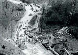
Figure 14. April 1952. Handwritten notes on back: “Group of 300 High School kids from Elkton and Reedsport doing their annual tree planting program — on private and BLM timberlands — this year on lands burned by the large Vincent Creek-Weatherly Creek Fire of 1951. Gathering for their lunch of hot dogs, ice cream, and sandwiches. (Led by Foresters from Coos Fire Patrol, Douglas Fire Patrol, and BLM.)” Photo and notes courtesy of Jerry Phillips, Coos Bay.
If reforestation projects can be made to mimic early historical vegetation patterns, in which wildfires were far less severe, then a network of strategic firebreaks can also be maintained by the same methods: periodic burning, pruning, harvesting, and firewood gathering. These conditions were maintained wherever people lived and traveled: along ridgelines and streamsides, the perimeters of lakes and the mouths of rivers. These functional firebreaks represented a relatively small percentage of the landscape, but created a safe, stable condition in which most conifers grew in even-aged subbasin stands, often surrounded by established trails, campgrounds, oak woodlands, grass prairies, berry fields, and/or camas meadows.
The common goals of reforestation planning, then, can be measured in jobs, profits, taxes, wildlife populations, and recreational visitor days — and safety, aesthetics, clean water, clean air, and public access. Wildfire mitigation must also be included.
B. Subbasin-scale road and trail maintenance
Road and trail access is the most critical consideration in the active management of forested properties and is also important to consider regarding the management of future wildfires, floods, landslides, ice storms, snowstorms, windstorms, and their aftermaths. Roads and trails that follow ridgelines and streambanks have the most strategic importance, and forest treatments should be considered that use the existing road network to actively create a system of ready-made firebreaks.
Road maintenance on federal lands directly affects the success rate of initial attack on forest fires. Likewise, road decommissioning should be weighed against the risk of losing suppression access to an area. There is evidence, for example, that firefighters were unable to attack lightning strikes that ignited the 2021 Rough Patch Complex because of recently decommissioned roads. Immediately following a fire, roads are often blocked by fallen (and falling) limbs and trees and travel can be very dangerous within the area until these problems have been resolved.
A new tool for dealing with these situations is the video drone (Figure 15). An operator can guide the drone along affected trails, roadways, and streams at eye- level and produce a very useful and permanent record for road maintenance, potential timber buyers, forest managers, scientists, and interested public.
The use of video drones is safer, much cheaper, and can provide far more detail than visiting the area by vehicle or observing it from the air. Further, drones can be programmed to travel identical routes over time, providing an excellent method for periodically monitoring reforestation projects, changing road and trail conditions, floods, landslides and/or forest growth and mortality.
Rock roads may be gated on industrial timberlands to reduce vandalism, while on federal lands they may be deliberately abandoned or made inaccessible. The same situation exists for recreational trail networks on public forestlands, so managing or avoiding large-scale wildfires on federal properties can be unnecessarily costly or even made impossible by these decisions.
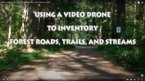
Figure 15. Opening sequence to 14-minute instructional video prepared for 2020 spring-term Southwestern Oregon Community College forestry class just prior to pandemic “distance-learning” restrictions (Zybach and Mahoney 2019).
C. Site prep and weeding
A large-scale wildfire typically leaves more fuel in its wake than what it consumes. In addition to snags, singed brush, and logs, these fuels often include undesired weeds such as Scotch broom, Himalayan blackberries, tansy ragwort and exotic grasses that can be rejuvenated by Prior to beginning planting, seeding, or other forest regeneration practices, it is important to do something regarding these residual fuels and unwanted competitive vegetation. This process is often referred to as “site preparation” or “site prep” (Fraser 1982).
Perhaps the most efficient method of preparing a post-fire subbasin for planned reforestation is “slash and burn” (Figure 16). This process uses prescribed fire to remove flash fuels, ground fuels, ladder fuels, and other flammable debris such as snags, tops, limbs, and twigs from an area. “Slashing” refers to the practice of uniformly cutting snags, shrubs, limbs and other unmerchantable plant materials to less than a two-foot-or-so level over an entire area scheduled for regeneration. The area is then “broadcast burned” to remove as much of this material as possible.
Sometimes fuels also consists of green trees and shrubs that can be allowed to dry, or desiccated with chemicals, before burning to improve project efficiency and quality and to further help reduce visible smoke and smoldering from the fire.
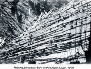
Figure 16. “Slash and burn” site preparation for weeding, tree planting, and stand maintenance, Yaquina River basin, near Elk City (Zybach 1981: 6).
Unwanted residual plants and materials remaining from a wildfire can also be “mechanically treated” on flat or sloping ground with a bulldozer or other equipment. Typically, a toothed blade is used to uproot, pile and/or “wind-row” surface and subsurface areas, leaving mostly bare soil behind for planting or seeding.
While piles and windrows of concentrated fuels are usually burned during Winter or Spring when wildfire risks are minimal; broadcast burning is often best done during the Summer and Fall fire seasons. Fires are usually more effective at clearing unwanted fuels during these times, and hotter burns also result in safer and better smoke management conditions. Another value is that thousands of generations of native plants and animals have adapted to this seasonal fire timing and often even benefit by this practice.
Exotic forest weeds are typically found in two locations: along roadways and along waterways. They also are typically rejuvenated by wildfire and can sprout and reseed after fires with little competition and with full sunlight. This exposure is when they are most vulnerable to location and treatment, whether by herbicides or mechanical methods where herbicides may not be allowed.
Roads and trails are prime locations to introduce weeds via people, vehicles, pets, and pack animals. These locations also make unwanted plants easier to locate and remove. Weed seeds that enter waterways, though, can then spread to streambanks from their point of entry all the way to the ocean if they are not treated. In recent decades this latter process has been exacerbated by the artificial creation of undisturbed “buffer strips,” as illustrated by Figure 11. Many miles of these streams are now bordered by dangerous flash fuels, such as reed canary grass and Himalayan blackberries, which were a primary fuel along the Bear Creek Greenway in the deadly 2020 Almeda Drive Fire (Zybach 2021b).
D. Strategic planting
Once a reforestation plan has been developed, access roads and trails opened, desired species determined, and designated sites identified and prepared, then successful planting and seeding is almost guaranteed. One surprising problem with the Labor Day Fires is that they were largely fueled by uniform plantings or thinnings of young trees — typically these were privately owned and actively managed lands with little recent history of wildfire.
One of the major reasons for the unusual burning of managed tree plantations is the contiguous canopy of pitchy, flammable conifers that are formed in accordance with State regulations and projected timber markets. When an area in western Oregon is first burned or logged it might contain a dozen, or maybe 50 or 60, merchantable conifers per acre; often growing in clusters and strips with open ridgelines and/or streambanks. It is then quickly planted with hundreds of trees per acre, usually in a solid grid-like pattern of Douglas fir seedlings, to meet economic goals and State regulations.
An alternative approach is to mimic early historical forest patterns, which were generally far less susceptible to catastrophic-scale “crown fires,” such as the Labor Day Fires. This approach could feature open ridgelines and riparian areas with native hardwoods — such as oak, ash, alder, myrtle, madrone, and cottonwood — in key locations. Restored camas and beargrass meadows, grassy prairies, and huckleberry fields have proven recreational and commercial potentials and can serve as effective firebreaks during wildfires or controlled burns. The presence of sunlight, grasses, berries, wildflowers, and nuts also provides good wildlife habitat.
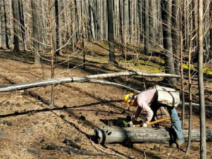
Figure 17. Contract labor crew member planting tree seedlings within stand of USFS Archie Creek Fire snags. Photo by Adrienne Barcas, USFS (Missett 2022).
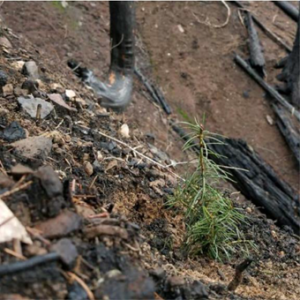
Figure 18. Planted Douglas fir seedling in Archie Creek burn. Photo by Barcas, USFS (Missett 2022). This is a low-grade Douglas fir seedling that has hardly any chance of living very long. The slender stem and under- sized terminal bud indicate it will not likely grow much this first year; the temporary absence of nearby vegetation makes it a target for small mammals and grazing ungulates; fast-growing weeds can easily shade it out; and adjacent snags makes a reburn very likely, if it is not eaten first.
These results could be achieved without significant reduction in area devoted to timber growth — and which can produce desired product volumes with far fewer plants per acre. Instead of commonly planting trees in eight-, 10- or 12-foot grids (300 to 660 seedlings/acre) and then precommercially thinning these trees to 150 to 200 trees/acre after 10 or 15 years, it makes greater economic sense to only plant 150 or 200 trees/acre in the first place. This can be readily accomplished by using “micro-site” densities to determine planting locations and using high-quality “plug- 1” seedlings that can be grown in less than two years and typically have 90- or 95- percent survival rates (Zybach 2012; 2021c).
In areas of likely animal damage to planted seedlings (whether from mice, rabbits, mountain beaver, deer, and/or elk) a combination of animal control (e.g., poison, trapping, hunting) and protective devices is generally undertaken — although use of poisons has been largely avoided for many years and trapping has also greatly decreased during that time.
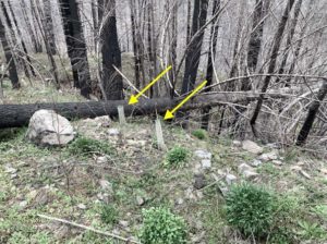
Figure 19. “Staked and tubed” seedlings (arrows) planted on BLM land in the Rock Creek basin following Archie Creek Fire (photo by Hill, DTO, April 2022).
Figure 19 shows a common method of using bamboo stakes, vexar tubing, and twist ties to protect individual seedlings from animal damage. This process adds considerable cost to planting trees, including maintenance, and it appears that standing snags, competing weeds, and rocks will make the future of these seedlings problematic. Why they are planted so close together is another question.
E. Regular plant maintenance
A functional reforestation plan should include a long-term maintenance strategy involving regular monitoring (see Figure 15), disease and pest control, occasional pruning, thinning, weeding, and situational salvage. Prescribed burning must also be considered for these purposes and clearly outlined in the plan where and why it is intended.
Much of western Oregon — including lands affected by the Labor Day Fires — is composed of native plants and animals that have adapted to regular broadcast burning over thousands of years. We now typically refer to these practices as “Indian burning” if done in a traditional, historical manner, or as “prescribed burning” if done by modern management plan. In the late 1800s, for example, early forest scientist John Leiberg recorded the “annual” broadcast burning of “yellow pine” forests south and east of the Archie Creek Fire, in areas occupied at that time by local Indian families and other, more recent, residents (Leiberg 1899: 249):
The forest floor in the [“yellow-pine”] type is covered with a thin layer of humus consisting entirely of decaying pine needles, or it is entirely bare. The latter condition is very prevalent east of the Cascades, where large areas are annually overrun by fire. But even on the western side of the range, where the humus covering is most conspicuous, it is never more than a fraction of an inch in thickness, just enough to supply the requisite material for the spread of forest fires.
Leiberg’s observations were limited to southwestern Oregon as far north as Crater Lake and were specific to, but did not include, the generally steeper and more voluminous Douglas fir stands, such as fueled much of the Labor Day Fires to the northwest. In these latter locations, Indian burning practices were generally confined to valley floor oak savannahs, firewood gathering, burning along ridgelines and streambanks, and rejuvenating berry fields and grassy prairies.
Figures 20 and 21 show the effects of the Archie Creek Fire on two adjacent stands on its southwestern border along the Thunder Mountain ridgeline in Tsp. 26 S., Rng. 2W. (see Map 2). These stands are within walking distance of each other and
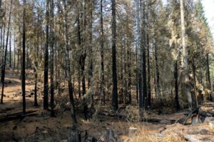
Figure 20. October 2020 picture depicts unthinned, roadside forest stand on BLM land near Thunder Mountain (photo by Hill, DTO).
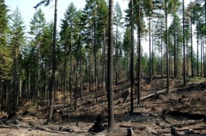
Figure 21. October 2020 picture depicts adjacent roadside stand on BLM land that was thinned according to prescription, ca. 2015 (photo by Hill, DTO).
F. Forest management research opportunity
All western Oregon Labor Day Fires, including Archie Creek Fire, are historically significant for several reasons, including: the record number of acres burned; the consistency of major landownerships affected; and the common diversity of fuels (management practices), elevations, aspects, and slopes affected.
Another common denominator was the unusually heavy east winds, low humidity, and high temperatures that blanketed western Oregon and drove these fires. This combination of simultaneous events, common weather patterns, and mixed ownerships and management histories provides an unprecedented opportunity to study and consider current and future wildfire mitigation strategies.
Following the 500,000-acre Biscuit Fire in southwest Oregon, a pioneering effort was made by Oregon State University researchers to determine the role of active forest management in the spread and severity of that event (e.g., Donato, et al. 2009), and particularly in relation to the earlier 1987 Silver Complex Fire (Thompson et al. 2007: 10,746):
No previous study has compared fire severity in plantations and naturally regenerated vegetation of similar ages. Our findings are consistent with studies that show that site history influences fire severity . . . and with studies that have found an association of high- severity fire with conifer plantations . . . Our limited knowledge of the fuel characteristics at the time of the Biscuit Fire prevents us from separating the effects of logging and planting.
By the time rains began on September 18, 2020, the Archie Creek Fire had burned more than 130,000 acres, including approximately 64,000 acres of industrial tree farms, 40,000 acres of BLM O&C Lands, and 26,000 acres of the Umpqua National Forest. Unlike the Silver Complex and Biscuit Fires, each of these ownerships have excellent forest management records that are publicly available.
Further, the forests of the North Umpqua are far more representative of the Douglas Fir Region than the unique forestlands of the Klamath-Siskiyous and the Kalmiopsis Wilderness. Finally, the combined land ownership and catastrophic wildfire patterns of the Archie Creek Fire were closely replicated by several other western Cascades Labor Day Fires. Regional comparative analyses would be even more informative: What forestland patterns and conditions are most favorable to resist damage from wildfire? Are best for safely containing wildfires? Respond most favorably for wildlife and recreation?
Additional research on these topics would certainly seem timely and useful, and the opportunity is both unprecedented and potentially very valuable to future forest owners and managers. Given the diversity of ownerships and the potential value of such findings to both public and private interests, perhaps a long-term collaborative research project along these lines should be seriously considered.
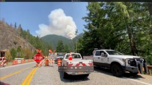
Figure 22. 2021 Jack Creek Fire plume, burning through snags remaining from the 2002 and later Apple Creek Fire(s), and stopping traffic along North Umpqua Highway 138, July 8, 2021. Videoclip by Peters, NW Maps Co.
G. Reevaluate federal land management designations
The framers of the 1994 Northwest Forest Plan created a concept they named LSR (“Late Successional Reserve”), in which large areas of federal forestlands would be passively managed with the least amount of human disturbance possible. There were 45 LSRs totaling three million acres created, and a million acres of new ACS (“Aquatic Conservation Strategy”) reserves, or “streamside buffers,” established by these designations. Changes also included the requirement that 10 miles of road be “decommissioned” for every new mile of roadway built, all resulting in an immediate reduction of more than 80% federal timber sales in the Pacific Northwest (Thomas et al., 2006).
There are about 10 million acres of federal forestlands in Oregon affected by the Northwest Forest Plan, including more than 3 million acres of Wildernesses, and a total of nearly 70% of the State’s public forests abruptly changed from timber-focused “sustained yield” and “multiple use” to passively managed lands based on ESA (Endangered Species Act) regulations. These changes quickly resulted in major economic hardships to rural families and businesses dependent on federal timber sales, and to major increases in the frequency, severity, and extent of large- and catastrophic-scale forest wildfires, as predicted (Zybach 1993; Petersen1994).
Federal land managers in western Oregon have been universally crippled before and after wildfire by the current suite of administrative land designations. The large majority of public forestlands (between 80-90%) has been set aside from active management — even following a catastrophic wildfire. This prevents managers from removing snags from areas that otherwise would make the most sense both economically and strategically.
For example, the portion of the Archie Creek Fire that burned on Forest Service land has been measured at 26,657 acres. Most of this land had been passively managed due to federal regulations since implementation of the Northwest Forest Plan: 50% was in an LSR, with overlapping designations of “Inventoried Roadless Areas” (44%) and “Wild & Scenic River” (13%). Of this total amount, less than 250 acres was scheduled for salvage (USDA USFS 2021) — that is, less than 1% of the estimated 850 mmbf of timber killed on the Umpqua NF in the Archie Creek Fire will be harvested or treated, and 99% will remain as dangerously risky, increasingly flammable, pitchy snags. And, in some areas, recently planted seedlings.
By leaving virtually 100% of snags in these areas following wildfires, federal agencies have been predictably sacrificing them to a likely half-century reburn cycle. As a result, many of these sites will be converted from complex conifer forests to persistent burns and shrublands (Hansen 1947) that do not support the species they were legally intended to favor. Whether people or other animals.
An entirely different approach needs to be employed by administrative or legislative means that addresses the greatest and most imminent threat to imperiled western Oregon wildlife species and rural communities: predictable wildfire.
ACKNOWLEDGEMENTS
This report was funded by Douglas Timber Operators (DTO), NW Maps Co., and David Gould, Coos Bay Timber Operators. I would like to thank Matt Hill, Executive Director, DTO; Dr. Dave Sullivan, President, Oregon Advocates for School Trust Lands; Bill Lansing, President/CEO, Menasha Forest Products Corporation (ret.); and McKenzie Peters, Editor, NW Maps Co., for timely and helpful reviews of this report; and Vyla Grindberg, Douglas County GIS Coordinator, for her excellent work in constructing the two report maps. Others who have provided helpful information, illustrations, quotations, or other assistance to this report are hopefully noted in the text, captions, and/or references. Naturally, all mistakes, errors, and omissions are my own.
REFERENCES
Adams, Phil 2021. Director of Timberlands, Roseburg Forest Products, videotaped interview with Matt Hill, Douglas Timber Operators, Roseburg, Oregon, August 2021.
Donato, Daniel, Joseph Fontaine, John Campbell, Douglas Robinson, Boone Kauffman and Beverly Law 2009. “Conifer regeneration in stand-replacement portions of a large mixed- severity wildfire in the Klamath-Siskiyou Mountains,” Canadian Journal of Forest Research, Vol. 39 (April 9): pp. 823-838. [PDF_1_MB]
DFPA (Douglas Forest Protective Association) 2012. The History of the Douglas Forest Protective Association, 1912-2012. State Printing Office, Salem, Oregon: 207 pp.
Fraser, Bruce 1982. “Site Prep,” A.R.C. Quarterly, Associated Reforestation Contractors, Inc., Vol. 1, No. 4 (Summer): 9-11. [PDF_5_MB]
Hansen, Henry P. 1947. Postglacial Forest Succession, Climate, and Chronology in the Pacific Northwest. Transactions of the American Philosophical Society, Vol. 37, Part 1: 130 pp. [PDF_53_MB]
Leiberg, John 1899. Cascade Range Forest Reserve from Township 28 South to Township 37 South, Inclusive, Together With the Ashland Forest Reserve and Forest Regions from Township 28 South to Township 41 South, Inclusive, and from Range 2 West to Range 14 East, Willamette Meridian, Inclusive. US Geological Survey, Government Printing Office, Washington, DC: 290 pp. Excerpts: http://www.orww.org/History/SW_Oregon/References/Leiberg_1899/
Metz, Dan 2021. Oregon Department of Transportation, Steamboat, Oregon. Personal communications, August 2021.
Missett, Kelly 2022. “Planting new hope in the Umpqua River basin,” National Partnership Office, USDA Forest Service “official website of the United States government” (June 10): https://www.fs.usda.gov/features/planting-new-hope-umpqua-river-basin
Nonaka, Etsuko and Thomas Spies 2005. “Historical Range of Variability in Landscape Structure: A Simulation Study in Oregon, USA,” IN: Ecological Applications, Ecological Society of America. Vol. 15, No. 5: 1727-1746. [PDF_7_MB]
Petersen, Jim 1994. “Voices in the Forest: An Interview with Bob Zybach,” Evergreen Magazine, (March-April): 7-22. [PDF_3_MB]
Petersen, Jim 2019. First, Put Out the Fire! The Evergreen Foundation, Coeur d’Alene, Idaho: 240 pp.
Sheley, Chuck, Editor, Smokejumper Magazine, National Smokejumper Association, Chico, California. Personal correspondence: July 2021.
Skrip, Pat, Director, Douglas Forest Protective Association, Roseburg, Oregon. Personal communications: July-August 2021; videotaped interview with Matt Hill, Douglas Timber Operators, Roseburg, Oregon, December 2020.
Thomas, Jack Ward, Jerry Franklin, John Gordon and K. Norman Johnson 2006. “The Northwest Forest Plan: Origins, Components, Implementation Experience, and Suggestions for Change,” Conservation Biology, Vol. 20, No. 2 (April): 277-287. [PDF_1_MB]
Thompson, Jonathon, Thomas Spies and Lisa Ganio 2007. Reburn severity in managed and unmanaged vegetation in a large wildfire,” Proceedings of the National Academy of Sciences, PNAS, Vol. 104, No. 25 (June 19): 10,743-10,748. [PDF_1_MB]
Thornton, Melvin, Director (Ret.) Douglas Forest Protective Association, Roseburg, Oregon. Personal communications: July-August 2021.
USDA RAT (Rapid Assessment Team) 2020. Archie Creek and Thielsen Fire Rapid Assessment Team Report: Umpqua National Forest North Umpqua and Diamond Lake Ranger District, October 19-20, 2020. USDA Umpqua National Forest, Roseburg, Oregon: 45 pp. [PDF_5_MB]
USDA USFS (US Forest Service) Umpqua National Forest 2021. Decision Memo: Burnt Creek Salvage Project. USDA North Umpqua Ranger District, Tiller, Oregon (sig/Sherri Chambers, August 20, 2021): 79 pp. [PDF_3_MB]
USDI BLM (Bureau of Land Management) 2014. Thunderbolt Hazardous Fuels Treatment Decision Record. BLM Swiftwater Field Office, Roseburg, Oregon District (sig/Jake Winn, August 1, 2014): 5 pp. w/map. [PDF_1_MB]
USDI BLM (Bureau of Land Management) 2020. 2020 Archie Creek Fire Emergency Stabilization and Burned Area Rehabilitation Plan. Bureau of Land Management, Roseburg District Office, Roseburg, Oregon (October): 117 pp. w/Appendices. [PDF_189_MB]
Zybach, Bob and Frank Mahoney 2019. Using a Video Drone to Inventory Forest Roads, Trails, and Streams. ORWWmedia, Oregon Websites & Watersheds Projects, Inc. June 27, 14:06: https://www.youtube.com/watch?v=ZDeE4s1Gj5c
Zybach, Bob and John Marker 2013. “The True Cost of Wildfire & The Douglas Complex,” Oregon Fish & Wildlife Journal, Vol. 35, No. 4 (Fall): 31-37. [PDF_2_MB]
Zybach, Bob 1981. “Safety and Profit,” A.R.C. Quarterly, Associated Reforestation Contractors, Inc., Vol. 1, No. 1 (Fall): 12-13. [PDF_3_MB]
Zybach, Bob 1982. “Reforestation: A Look into The Future of Contract Logging,” The Log, Associated Oregon Loggers, Inc., Vol. 6, No. 6 (November): 26-28, 37-39. [PDF_3_MB]
Zybach, Bob 1983. “Renewed Resources: The Reforestation of the Tillamook Burn (1948- 1983),” A.R.C. Quarterly, Associated Reforestation Contractors, Inc., Vol. 3, No. 3 (Fall): 13-
- [PDF_4_MB]
Zybach, Bob 1993. Forest History and FEMAT Assumptions: A Critical Review of President Clinton’s 1994 Northwest Forest Plan, American Forest and Paper Association and Northwest Forest Resource Council, Portland, Oregon (Rev. March 20, 1994): 101 pp. [PDF_77_MB]
Zybach, Bob 2003. The Great Fires: Indian Burning and Catastrophic Forest Fire Patterns of the Oregon Coast Range, 1491-1951. Oregon State University PhD dissertation, Corvallis, Oregon: 451 pp. [PDF_60_MB]
Zybach, Bob 2012. “Forest Restoration: Problems and Opportunities,” Oregon Fish & Wildlife Journal, Vol. 34, No. 2 (Spring): 15-27. [PDF_4_MB] [2019_3_MB]
Zybach, Bob 2016. “BLM Forest Planning: Putting the Quotation Marks in “Scientific” Management,” Oregon Fish & Wildlife Journal, Vol. 38, No. 2: 17-25. [PDF_2_MB]
Zybach, Bob 2017. “2017 Oregon Forest Fires: Still Predictable and Preventable,” Oregon Fish & Wildlife Journal, Vol. 39, No. 4 (Fall): 31-39. [PDF_3_MB]
Zybach, Bob 2021a. “Guest Editorial: The Coming Firestorms,” Oregon Fish & Wildlife Journal, Vol. 43, No. 1 (Winter): 5. [PDF_3_MB]
Zybach, Bob 2021b. “Western Oregon’s 2020 Labor Day Fires,” Oregon Fish & Wildlife Journal, Vol. 43, No. 1 (Winter): 31-41. [PDF_3_MB]
Zybach, Bob 2021c. “Reforestation of the 2020 Labor Day Fires in Western Oregon,” Oregon Fish & Wildlife Journal, Vol. 43, No. 2 (Spring): 31-41. [PDF_3_MB]
Zybach, Bob 2021d. “The Snags of the North Umpqua: Part 1. Future Risks,” Oregon Fish & Wildlife Journal, Vol. 43, No. 4 (Fall): 33-45. [PDF_5_MB]
Zybach, Bob 2022. “The Snags of the North Umpqua: Part 2. Forest Restoration,” Oregon Fish & Wildlife Journal, Vol. 44, No. 1 (Winter): 33-43. [PDF_5_MB]
Authored by Bob Zybach and originally published at NW Maps Co. on 26 January 2022 here.
Bob Zybach is a Member of the CO2 Coalition. He is a writer, researcher and photographer with a focus on the human and landscape history of Oregon. His degrees are PhD (Environmental Sciences, MA (History) and BS (Forestry).